
Advertisement
-
Published Date
November 17, 2022This ad was originally published on this date and may contain an offer that is no longer valid. To learn more about this business and its most recent offers, click here.
Ad Text
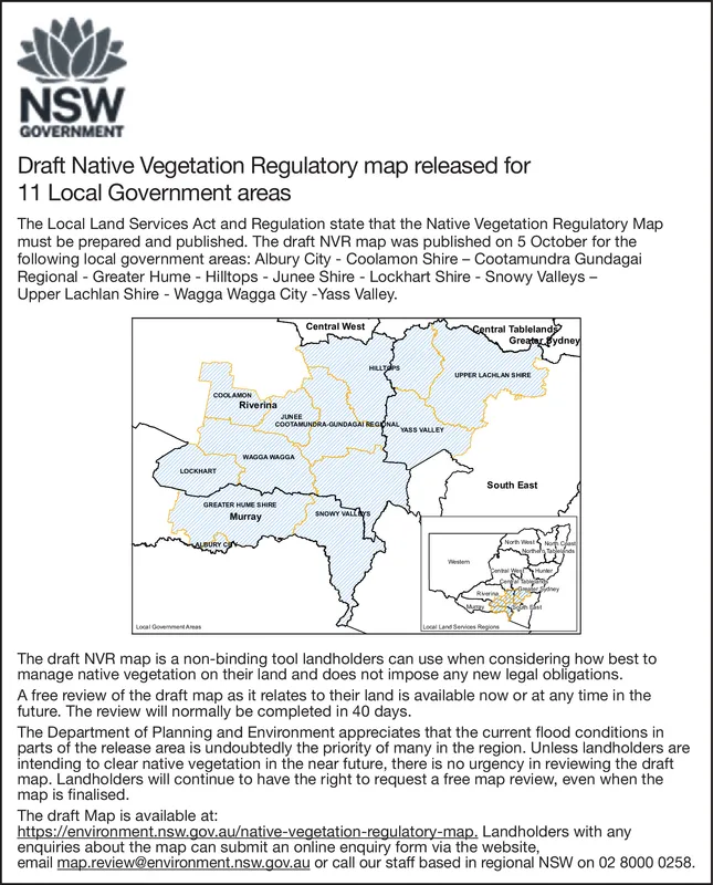
NSW GOVERNMENT Draft Native Vegetation Regulatory map released for 11 Local Government areas The Local Land Services Act and Regulation state that the Native Vegetation Regulatory Map must be prepared and published. The draft NVR map was published on 5 October for the following local government areas: Albury City - Coolamon Shire - Cootamundra Gundagai Regional - Greater Hume - Hilltops - Junee Shire - Lockhart Shire - Snowy Valleys - Upper Lachlan Shire - Wagga Wagga City -Yass Valley. COOLAMON LOCKHART Local Government Areas ALBURY Riverina JUNEE GREATER HUME SHIRE Murray WAGGA WAGGA Central West COOTAMUNDRA-GUNDAGAI REGIONAL HILLTS SNOWY VALLAS YASS VALLEY Central Tableland Greater Sydney UPPER LACHLAN SHRE South East Cenital We Hunter Rain North West C Local Land Services Region Sydney The draft NVR map is a non-binding tool landholders can use when considering how best to manage native vegetation on their land and does not impose any new legal obligations. A free review of the draft map as it relates to their land is available now or at any time in the future. The review will normally be completed in 40 days. The Department of Planning and Environment appreciates that the current flood conditions in parts of the release area is undoubtedly the priority of many in the region. Unless landholders are intending to clear native vegetation in the near future, there is no urgency in reviewing the draft map. Landholders will continue to have the right to request a free map review, even when the map is finalised. The draft Map is available at: https://environment.nsw.gov.au/native-vegetation-regulatory-map. Landholders with any enquiries about the map can submit an online enquiry form via the website, email map.review@environment.nsw.gov.au or call our staff based in regional NSW on 02 8000 0258. NSW GOVERNMENT Draft Native Vegetation Regulatory map released for 11 Local Government areas The Local Land Services Act and Regulation state that the Native Vegetation Regulatory Map must be prepared and published . The draft NVR map was published on 5 October for the following local government areas : Albury City - Coolamon Shire - Cootamundra Gundagai Regional - Greater Hume - Hilltops - Junee Shire - Lockhart Shire - Snowy Valleys - Upper Lachlan Shire - Wagga Wagga City -Yass Valley . COOLAMON LOCKHART Local Government Areas ALBURY Riverina JUNEE GREATER HUME SHIRE Murray WAGGA WAGGA Central West COOTAMUNDRA - GUNDAGAI REGIONAL HILLTS SNOWY VALLAS YASS VALLEY Central Tableland Greater Sydney UPPER LACHLAN SHRE South East Cenital We Hunter Rain North West C Local Land Services Region Sydney The draft NVR map is a non - binding tool landholders can use when considering how best to manage native vegetation on their land and does not impose any new legal obligations . A free review of the draft map as it relates to their land is available now or at any time in the future . The review will normally be completed in 40 days . The Department of Planning and Environment appreciates that the current flood conditions in parts of the release area is undoubtedly the priority of many in the region . Unless landholders are intending to clear native vegetation in the near future , there is no urgency in reviewing the draft map . Landholders will continue to have the right to request a free map review , even when the map is finalised . The draft Map is available at : https://environment.nsw.gov.au/native-vegetation-regulatory-map . Landholders with any enquiries about the map can submit an online enquiry form via the website , email map.review@environment.nsw.gov.au or call our staff based in regional NSW on 02 8000 0258 .